

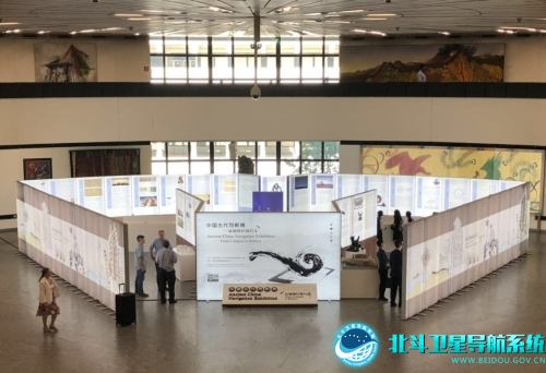
Invited by the United Nations Office for Outer Space Affairs (UNOOSA), the Chinese Delegation and the China Satellite Navigation Office (CSNO) jointly organize the China Ancient Navigation Exhibition in the Annular Hall of Vienna International Centre, and donate some of exhibits to UNOOSA. More than eighty delegates including H.E. Wang Qun, the Chinese permanent representative to the UN in Vienna, Vice Director Hu Bin of Department of Articles and Laws in Ministry of Foreign Affairs of the People’s Republic of China, Director Simonetta Di Pippen of UNOOSA, Vice Director Ma Jiaqing of CSNO, and delegates of China National Space Administration (CNSA), representatives of satellite navigation providers from USA and Russia attended the opening ceremony of the Exhibition and the donation ceremony of the exhibits on 11st, June.

Ambassador Wang Qun, Director Di Pippen, and Vice Director Ma Jiaqing delivered speeches respectively at the opening ceremony. Vice Director Ma Jiaqing and Director Di Pippen exchanged the exhibit donation agreement as well. According to the agreement, The South-pointing Cart and the Odometer Drum will be permanently displayed in the exhibition area of The United Nations Building. After the opening ceremony, Ambassador Wang Qun and Director Di Pippen visited the exhibition and gave a high appraisal. They expressed that Chinese long navigation culture and modern advanced navigation technology had made important contributions to the development of the world satellite navigation.
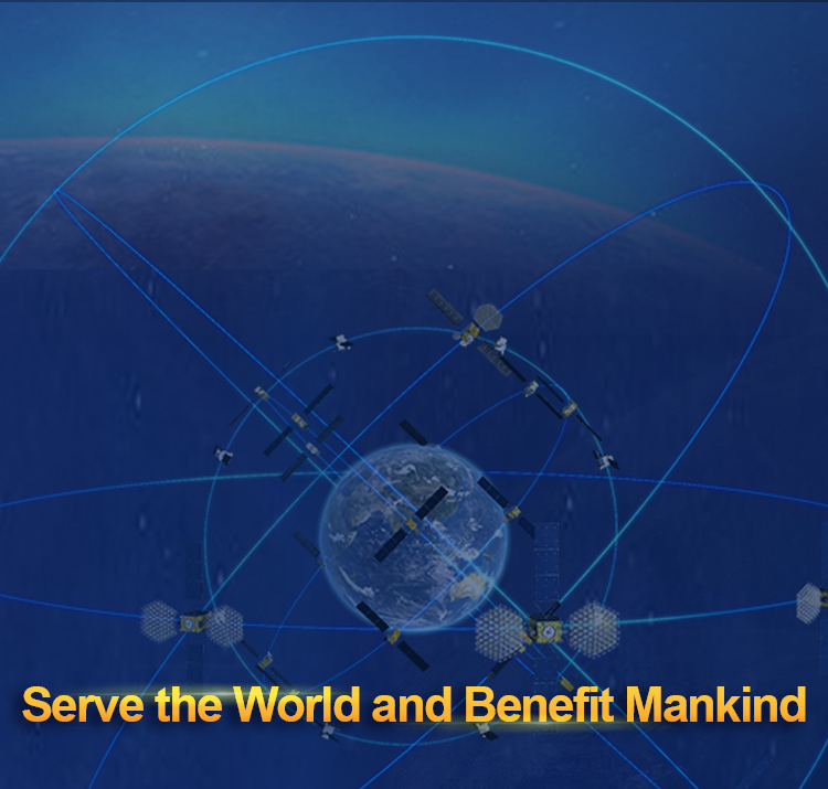
With an area of about two hundred square meters, the theme of the exhibition is “From Compass to BeiDou”, which is divided into five parts, including “Time Service”, “Navigation”, “Surveying and Mapping”, “Communications along the Belt and Road”, and “BDS, serving the world and benefiting mankind”. With exhibition boards, exhibition kind and so on, the exhibition vividly demonstrates the brilliant achievements made by Chinese people in time service, surveying, mapping, and navigation science and technology over the past five thousand years. It shows that the Chinese ancient navigation technologies played an inestimable role in guiding the production and life of the working people and exploring the unknown world. It is strongly proven that using navigation technologies as a link, the Silk Road and the Maritime Silk Road connecting China with the rest of the world have never been interrupted for thousands of years. The wisdoms and contributions of the Chinese people have greatly promoted the integration and communication of Eastern and Western civilizations and the progress and development of human society. Meanwhile, it demonstrates the construction and development achievements and the progresses of international cooperation of the BDS program, declares the attitude and determination of China to actively advocate the establishment of a community of human destiny in space-time datum field, and further elaborates the BDS development concept, namely “the China’s BeiDou, the World’s BeiDou, and a Top-class BeiDou”. As one of the most important activities in the conference of Committee on the Peaceful Uses of Outer Space (COPUOS), China Ancient Navigation Exhibition will be held from 11th June to 21st June.
By the end of 2018, the BDS-3 preliminary system was completed to provide global services. The international community highly praises the achievements of the Chinese satellite navigation industry and pays close attention to the BDS development. The exhibition and related conferences and exchanges have promoted the countries from all over the world to have a deep understanding of the Chinese navigation technological culture and the latest achievements in the BDS construction, and have expressed the hope that BDS will strengthen exchanges and cooperation with other countries in the world, share the achievements of construction and development with other countries, and promote the vigorous development of global satellite navigation.
As the official name of the China’s independently constructed satellite navigation system, BeiDou, intends to inherit the traditional genes of the Chinese navigation technology culture. In the design of the BDS logo, the circular configuration symbolizes "perfection". Combined with a Tai Chi “Yin Yang Fish”, it is in line with the traditional Chinese culture. The dark blue space and light blue earth represent the space industry. The Big Dipperis the basis for people to identify orientations since ancient times, and Sinan is the earliest navigation device invented in the ancient China. The combination of the two not only shows the ancient Chinese science technological achievements, but also implies the integration of satellite and earth for a satellite navigation system. The networked earth and the BDS name in both of Chinese and English also symbolize the BDS vision of openness, compatibility, and serving the whole world.

